Buildable Area: A Faster Path from Map to Project
Every solar or storage project starts with the same basic question: “Can we build here?”
Traditionally, answering that question has been a painful process. Developers spend hours toggling layers on and off, manually drawing polygons around exclusion zones, and checking the same parcels more than once. When those parcels finally make it to engineering, many turn out to be dead ends. It wastes time, creates duplication, and leaves teams frustrated.
That’s why we’re introducing a new feature in Glint Solar: Buildable Area.
A simpler way forward
Buildable Area takes the guesswork and manual effort out of early site screening. Instead of redrawing the same shapes and repeating the same checks, you can define your rules once, save them as a constraint profile, and run a calculation with a single click.
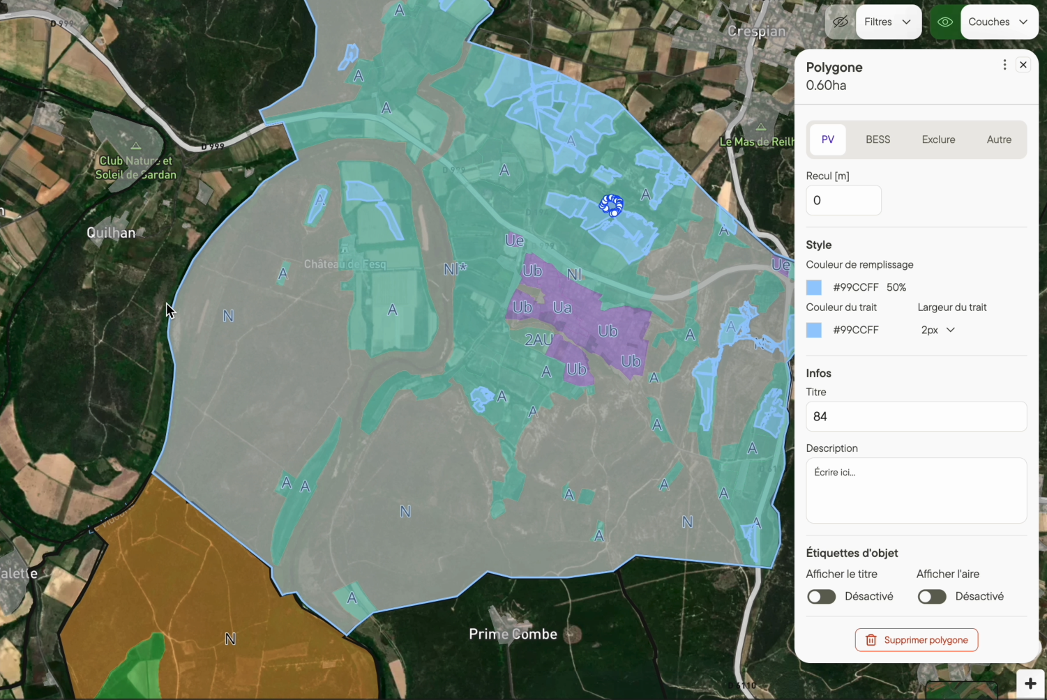
The result is a clear footprint: areas where you can build are shown in green, and exclusion zones are shaded in gray. By turning messy maps into actionable insights, Buildable Area makes it easier to see which sites are worth pursuing and which ones you can confidently set aside.
What you gain
With Buildable Area, teams move faster and with more certainty. Decisions that once took hours now take minutes, allowing you to screen more sites in less time. Because profiles are applied consistently, different team members get the same result no matter who runs the calculation. And perhaps most importantly, engineers no longer waste valuable hours working on projects that will never get built.
The impact is clear: less rework, more consistency, and a pipeline that advances projects with genuine potential.
How it works in practice
Using Buildable Area is simple. First, you choose the parcels you want to evaluate. This could be a single plot or multiple adjoining parcels from the same landowner. Next, you apply a constraint profile — for example, excluding slopes above 12%, buffering wetlands by 30 meters, or avoiding proximity to waterways.
With one click, the calculation runs and instantly shows you the buildable footprint in green. From there, you can export the results, share them with colleagues, or move directly into a first-pass layout. It’s the same process you’ve been doing manually, but much faster, more consistent, and less prone to error.
Real-world examples
Imagine a developer in Pennsylvania evaluating 50 parcels from one landowner. In the past, that would have required hours of manual drawing and checking. With Buildable Area, they apply wetlands and steepness buffers once, run the calculation, and immediately rule out 30 parcels. The team can focus only on the 20 that show real potential.
Or take a developer in France, where planning rules like RPG 2023 need to be accounted for. By applying a steepness limit of 12% and the planning constraints in one profile, their first-pass layout only places panels on compliant land. That saves the engineering team from wasting days on redesigns.
Finally, consider a project that’s already underway. New Natura 2000 boundaries are published. Instead of redoing the screening process from scratch, the developer re-runs Buildable Area with updated constraints and gets an accurate new footprint within seconds.
Where it’s available
Buildable Area is being released in stages. As of today, it will be available for France and for 3 U.S. states: Rhode Island, Pennsylvania, and Ohio. Germany will follow shortly after, with more geographies on the roadmap.
Ready to see it?
If you’re already a Glint Solar customer, Buildable Area is auto enabled per your portfolio's set geography. If you have France and/or the 3 US States enabled, you can try it right away.
If you’re not yet a customer, this is the perfect moment to learn more. Request a demo and see how Buildable Area helps you move from messy maps to confident projects giving you the confidence to make fast decisions.